- Eta made landfall in central Cuba early Sunday.
- The system is expected to approach Florida tonight with rain, wind, storm surge and high surf.
- Locally heavy rain may persist in Florida into Tuesday.
Tropical Storm Eta is moving back over water after tracking across Cuba, and will make its closest approach to South Florida tonight, possibly as a hurricane, producing flooding rain, storm surge, strong winds and high surf.
(MAPS: Latest Eta Map Tracker Page)
Eta made landfall in Cuba early Sunday morning as a tropical storm, as indicated by radar from Cuba's Institute of Meteorology. The center of Eta has now moved back over water and is located just offshore of the east-central coast of Cuba.
Current Wind Watches and Warnings
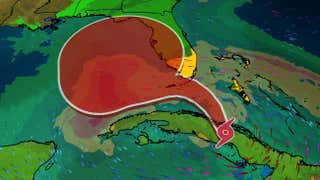
A hurricane warning and storm surge warning is in effect for the Florida Keys from Ocean Reef to the Dry Tortugas, including Florida Bay. Hurricane conditions are expected here by early Monday and there is a danger of life-threatening inundation during the next 36 hours.
Tropical storm warnings have been issued for much of central Cuba, the northwestern Bahamas and South Florida from the Brevard-Volusia County line to Englewood. This includes Nassau, Grand Bahama Island, the entire Miami metro area and the Florida Keys. This is where tropical storm conditions are expected generally through Monday.
A hurricane watch is in effect for the coast of southern Florida from Deerfield Beach to Bonita Beach. Hurricane conditions are possible in this area Sunday night and Monday.
A tropical storm watch is in effect along the Florida west coast from Englewood to Anna Maria Island, as well as for parts of western Cuba, including Havana. Tropical storm conditions are possible in these areas.
A storm surge watch for the coast of southern Florida from Golden Beach to Bonita Beach, including Biscayne Bay. A dangerous storm surge is possible in this area.
Watches, Warnings
(A watch is issued when tropical storm or hurricane conditions are possible within 48 hours. A warning is issued when those conditions are expected within 36 hours.)Happening Now
Bands of rain continue to feed into the Florida Keys and South Florida with gusty winds and heavy rain at times.

Current Radar
There were a number of reports of wind gusts from 40 to 50 mph across South Florida Saturday and early Sunday. One band of showers produced a 53 mph wind gusts east-northeast of Dania Beach in Broward County Saturday.

Forecast Details
Here's the latest forecast path of the center of Eta for the next five days from the National Hurricane Center.

Current Information
(The red-shaded area denotes the potential path of the center of the tropical cyclone. It's important to note that impacts (particularly heavy rain, high surf, coastal flooding, winds) with any tropical cyclone usually spread beyond its forecast path.)Eta is expected to track northward toward South Florida as a strong tropical storm or possibly a hurricane Sunday night into early Monday.
After that, Eta is expected to turn west and may meander in the eastern Gulf of Mexico for several days.
Intensity Forecast
Near Florida, Eta's strength will depend on if dry air penetrates into Eta's inner core. Some vertical wind shear along with land interaction has weakened this storm and will also cause it to have an uphill battle in order to strengthen.
Eta's interaction with dry air and/or wind shear in the Gulf of Mexico is expected to keep a lid on its intensification while it is in the Gulf of Mexico.
Track Forecast
Several weather features will play pinball with Eta over the next few days.
Eta will be steered northward then westward toward South Florida Sunday by the counterclockwise flow around an upper-level low-pressure system located in the Gulf of Mexico.
Eta may then lose steering influences, meaning it may slow down significantly or even stall west of Florida's West Coast.
Eventually, Eta may make a final landfall somewhere along either Florida's Gulf Coast or the northern Gulf Coast late in the week, as it finally accelerates ahead of an approaching frontal system.
However, there are some forecast model solutions that never bring Eta to land again, succumbing to the aforementioned dry air and/or shearing winds later in the week.
So, for now, residents along the Gulf Coast should simply monitor the latest forecast for Eta and check back for updates.
Forecast Impacts
Rainfall
Eta is expected to produce the following rainfall totals through Thursday, according to the National Hurricane Center (NHC):
-Parts of the central and southern Florida Peninsula, including the Florida Keys: 6 to 12 inches, with isolated totals to 18 inches
-The Bahamas: An additional 4 to 8 inches, with isolated totals to 15 inches
-Parts of Cuba: An additional 2 to 5 inches, with isolated totals to 25 inches
-Jamaica: An additional 1 to 3 inches, with isolated storm totals to 15 inches
This could lead to significant flash flooding in all these areas, with a threat of landslides possible in areas of higher terrain.
Flood watches are in effect through Tuesday evening in South Florida, including the Miami-Ft. Lauderdale metro area, which received heavy rain last month.
Eta has already unleashed deadly flooding and landslides as it passed over the mountainous terrain of Central America, particularly in Honduras. For more details on the flooding, check out our latest news article linked below.
(MORE: Eta Devastates Central America)

Rainfall Forecast
(Heavier amounts may occur where bands of rain stall for a period of several hours. )Storm Surge
In general, modest storm surge flooding is expected along the coast of Florida. Here are the latest peak storm surge values from the NHC if they occur at high tide.
It should be noted coastal flooding may occur through multiple high tide cycles, particularly on the Gulf side and in the Florida Keys into at least Tuesday, if not longer.

High Surf, Rip Currents
The gradient between high pressure near the eastern U.S. and Eta's lower pressure will generate gusty winds blowing onshore along Florida's East Coast the next several days.
That will allow high surf and dangerous rip currents to increase from Florida's East Coast to possibly as far north as southern North Carolina, peaking Sunday into Monday, but lingering in some of those areas into late week. Coastal flooding is likely in some of these areas, particularly at high tide.
Eventually, surf may begin to build along the northern Gulf Coast later this week, depending on the forecast for Eta.
Winds
Hurricane conditions are expected in the Florida Keys by early Monday morning.
Here is when tropical storm conditions are expected or possible, according to the NHC:
-Cuba: Sunday
-Northwest Bahamas: Through Sunday night
-South Florida, including the Florida Keys: Late Sunday through Monday

Tropical Storm Force Wind Probabilities
(Areas with at least a 20 percent chance of tropical storm force winds are contoured above, from the National Hurricane Center. The most likely time of arrival of those winds are shown by the black lines, labeled by approximate times in EST. )Damage is possible along small portions of the Florida coastline where winds gust over 60 mph. For most Floridians in the southern portion of the state, windy conditions are expected Sunday and Monday.
Here's is a general timeline of when the strongest gusts may occur:

Also, as is often the case with tropical cyclones affecting land, a few tornadoes are possible in South Florida through Monday.
Check back to weather.com for updates to the forecast over the next few days.
Central America Rainfall Flood Catastrophe
Nicaragua and Honduras have seen roofs ripped off of homes, trees uprooted, bridges washed out, landslides and flooded roads.
As feared, torrential rain from Eta triggered massive flooding in parts of Central America.
One of the hardest-hit areas was western Honduras.
Flooding inundated Ramón Villeda Morales International Airport near San Pedro Sula, Honduras.
Water was up to the rooftops in parts of San Pedro Sula, Thursday. Video showed hundreds of people on rooftops and the second story of buildings waiting for rescue. Some had been trapped for 48 hours.
Water levels along the Ulúa River in western Honduras were said to have been 13 feet higher than the peak during Hurricane Mitch in 1998. Catastrophic flooding was also expected along the Choluteca River in the town of Marcovia, in southern Honduras, south of the capital Tegucigalpa.
(MORE: Eta Triggers Memories of Mitch 22 Years Ago)
One landslide in Guatemala reportedly claimed at least 100 lives.
Over 22 inches of rain was recorded in Tela on the Caribbean coast since Monday.
Some locations picked up over 10 inches of rain in one day, including Puerto Barrios, Guatemala (13.98 inches).
The NHC was forecasting storm totals could reach 40 inches in parts of Honduras and Nicaragua.

Eta's Storm History
Eta is the 28th storm of the 2020 Atlantic hurricane season, which ties the 2005 season for the most storms on record. It's also the 12th hurricane of the season, which ties for the second-most on record for a year in the Atlantic.

Maximum sustained winds in Eta increased from 70 mph to 150 mph in just 18 hours ending 7 p.m. EST Monday. That's more than double the criteria for the rapid intensification of a tropical cyclone, which is a wind speed increase of 35 mph or more in 24 hours or less.
At its peak late Monday and early Tuesday, Eta was the third-strongest November hurricane on record in the Atlantic by wind speed and just the fifth Atlantic Category 4 or higher hurricane to occur in the month. Paloma in 2008 was the last November Category 4 hurricane in the Atlantic.
Eta was the ninth storm of the 2020 Atlantic hurricane season to undergo rapid intensification.
Eta's central pressure plunged 82 millibars in 48 hours ending 1 a.m. ET Nov. 3, one of the largest 48-hour pressure drops on record in the Atlantic Basin, according to Sam Lillo, a NOAA researcher based in Boulder. Only hurricanes Andrew, Rita and Wilma had as large or larger pressure drops in a 48-hour period than Eta, Lillo found.
The small hurricane produced prolific lightning flashes in its eyewall Monday afternoon, one sign of its intensity.
Eta's eye arrived along the coast of Nicaragua about 15 miles south-southwest of Puerto Cabezas, Nicaragua around 4 p.m. EST Tuesday. At that time, maximum sustained winds were estimated at 140 mph, a Category 4 hurricane on the Saffir-Simpson hurricane wind scale, according to the NHC.
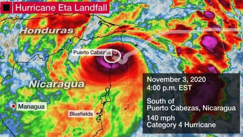
Eta was only the fifth Category 4 or stronger hurricane on record to landfall in Nicaragua, the first since Category 5 Hurricane Felix in 2007.
Winds had gusted up to 136 mph near Puerto Cabezas, Nicaragua, Tuesday afternoon.
The NHC forecasted a destructive storm surge inundation of 14 to 21 feet above normal tide levels near where Eta made landfall. This is roughly the magnitude of storm surge experienced during Category 5 Hurricane Felix in 2007.

People walk around a road blocked by a landslide in Purulha, northern Guatemala Friday, Nov. 6, 2020. As the remnants of Hurricane Eta moved back over Caribbean waters, governments in Central America worked to tally the displaced and dead, and recover bodies from landslides and flooding that claimed dozens of lives from Guatemala to Panama. (AP Photo/Moises Castillo)
The Weather Company’s primary journalistic mission is to report on breaking weather news, the environment and the importance of science to our lives. This story does not necessarily represent the position of our parent company, IBM.
World - Latest - Google News
November 08, 2020 at 10:45PM
https://ift.tt/359BDc5
Tropical Storm Eta to Brush South Florida Near Hurricane Strength With Flooding, Strong Winds | The Weather Channel - Articles from The Weather Channel | weather.com - The Weather Channel
World - Latest - Google News
https://ift.tt/2SeTG7d
Bagikan Berita Ini


0 Response to "Tropical Storm Eta to Brush South Florida Near Hurricane Strength With Flooding, Strong Winds | The Weather Channel - Articles from The Weather Channel | weather.com - The Weather Channel"
Post a Comment