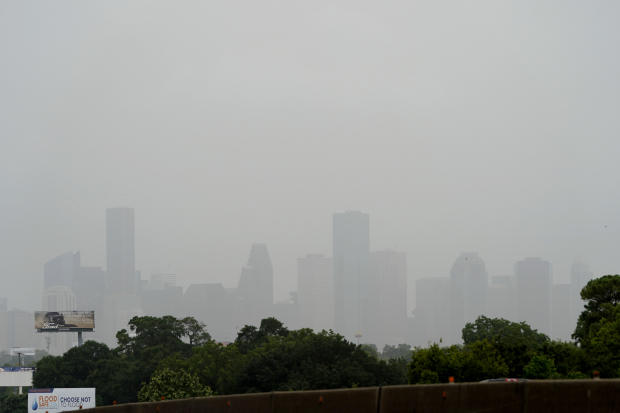
What's been called the most significant dust cloud in 50 years has now shrouded the U.S. Gulf Coast in a thick, dusty haze. The dust layer, which originated in the Sahara desert and drifted across the Atlantic, is forecast to continue moving north and east through the weekend, impacting areas from Texas and Florida all the way up to as far north as the Canadian border.
For most people, the dust will merely be a nuisance, but for many who have breathing issues the extra particulates in the atmosphere can cause complications. The timing couldn't be much worse, considering that a recent Harvard study shows that long-term exposure to fine particles of pollution in the air, much like dust, may be linked to higher rates of hospitalization and death due to COVID-19.
Currently the dust is thickest from Texas to Florida.
The dust is responsible for the dense haze shrouding Houston's skyline in the photo below.
Most of the dust layer exists far above the surface — mostly between a few thousand feet above the surface to about 15,000 to 20,000 feet up. However, vertical mixing of the atmosphere and rainfall can bring that dust to the ground, and that's when it can become harmful to people with respiratory issues.
In some places, like the Southeast, enough dust will settle that odds are people there will be able to see a thin layer of dust on their cars.
The dust plume is forecast to break into two chunks due to a split in steering flow in the mid levels of the atmosphere, which will act as a guide.
One part of the dust cloud will be pulled northward from Texas through the Plains States and Midwest this weekend, and even to the Canadian border on Monday morning. The dust will diffuse and thin out dramatically by the time it reaches the nation's middle, but cities like Kansas City, Minneapolis and Chicago will see a hazier than normal sky. The dust in the atmosphere will also make for some especially vivid sunrises and sunsets.
The other batch of dust will be thicker and linger in the South, impacting Texas and areas eastward and northeastward into the Tennessee Valley, the Carolinas and Florida. Here the dust will be thick enough to pose breathing risks. It is recommended that people in these areas wear a mask when outdoors.
This NASA animation below shows the progression of the dust through Sunday. The white areas are where dust will be the most dense; the blues and purples show where it will be more diffuse.
Now, dust has both negative and positive impacts.
On the positive side, for millions of years dust has been transported by the east-to-west trade winds from Africa across the Caribbean to Florida, supplying much of the soil, and nutrients in the soil, for growth of vegetation. Scientists believe that the nutrient load in the environment around Florida and the Bahamas is otherwise so poor that without the African dust, the coral reefs would have had a hard time growing and flourishing. Dust plumes also supply much of the nutrients to sustain life in the Amazon rainforest.
Naturally, due to the severity of this dust cloud, many are wondering if it has any connection to climate change. The evidence is mixed. As to whether this dramatic dust cloud was made worse by climate change, there is no clear answer yet. But the process of dust cloud formation can lend some clues.
Dust forms in the Sahara desert and on the edge of the more lush Sahel — a narrow transition zone between desert to the north and savanna to the south — in north Africa. There is evidence that these areas have been generally drying out and the desert has been expanding lately due partially to natural cycles and partially to human-caused climate change.
As the Earth warms, evaporation of surface water increases, drying out the Sahara and the northern fringe of the Sahel even more. A 2019 study did indeed find that dust transport increased in the last century compared to the last 2,000 years.
In the future, the climate models project mixed results in terms of decreased rainfall and increased heavy rain events in the area due to climate change. However, it seems virtually certain that even if there is more rain, it will not be enough to counteract the increased evaporation. Thus, the Sahara and Sahel will likely dry out even more. This would theoretically create more dust.
But, on the other hand, a study in 2016 found that the bigger controlling factor for dust clouds may be potential changes in the wind flow. In this case, the study finds in the future the tropical circulation may weaken due to global warming. Weaker winds would stir up less dust from Africa and thus dust clouds in the Atlantic would decrease.
Decreased dust in the tropical Atlantic may mean a warmer ocean, due to less dust blocking the sun. And less dry-dusty air could mean a better chance for hurricanes to form and intensify. But the jury is still out on that.
What is clear is that the atmospheric dust plays an important role in our lives, affecting everything from respiratory health to pretty sunsets, and from fertilizing coral reefs and forests to squelching hurricanes. Positive or negative, what this dust cloud episode teaches us, once again, is that everything on Earth is interconnected.
World - Latest - Google News
June 27, 2020 at 06:22AM
https://ift.tt/2NAY4x4
Saharan dust cloud cloaks U.S. Gulf Coast in choking haze - CBS News
World - Latest - Google News
https://ift.tt/2SeTG7d
Bagikan Berita Ini


0 Response to "Saharan dust cloud cloaks U.S. Gulf Coast in choking haze - CBS News"
Post a Comment