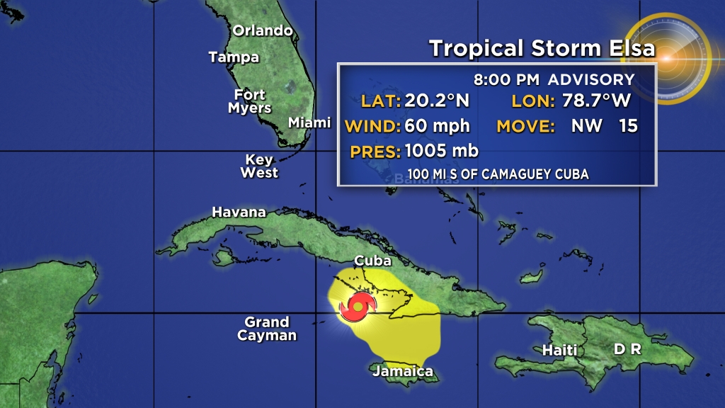
MIAMI (CBSMiami) – Tropical Storm Elsa is moving away from southeastern Cuba and Jamaica. It’s expected to move across central Cuba on Monday.
As of 8 p.m. Sunday, Elsa was 65 miles west of Cabo Cruz, Cuba and 100 miles south of Camaguey, Cuba.
READ MORE: Surfside Condo Collapse: Miami-Dade Mayor Confirms Demolition Will Happen Between 10 P.M. & 3 A.M.Its max sustained winds were 60 mph with higher gusts as it moves toward the northwest near 15 mph.
This general motion is expected to continue through Monday, followed by a turn toward the north-northwest on Tuesday.
On the forecast track, the center of Elsa will approach south-central Cuba late Sunday night and early Monday. Elsa is expected to move across central and western Cuba and head toward the Florida Straits on Monday, and pass near the Florida Keys early Tuesday.
Elsa is then forecast to move near or over portions of the west coast of Florida on Tuesday and Wednesday.
Some strengthening is expected before Elsa moves over Cuba, followed by some weakening while the center moves over land. Slight restrengthening is possible after Elsa moves over the southeastern Gulf of Mexico.
Tropical-storm-force winds extend outward up to 90 miles from the center.
SUMMARY OF WATCHES AND WARNINGS IN EFFECT:
A Hurricane Watch is in effect for:
- The Cuban provinces of Camaguey, Granma, and Las Tunas.
A Tropical Storm Warning is in effect for:
- The Cuban provinces of Camaguey, Granma, Guantanamo, Holguin, Las Tunas, Santiago de Cuba, Ciego de Avila, Sancti Spiritus, Villa Clara, Cienfuegos, Matanzas, Mayabeque, and Havana
- The Florida Keys from Craig Key westward to the Dry Tortugas
A Storm Surge Watch is in effect for:
- West coast of Florida from Bonita Beach to the Suwannee River
A Tropical Storm Watch is in effect for:
- Cayman Brac and Little Cayman
- The Cuban province of Artemisa
- The Florida Keys from east of Craig Key to Ocean Reef
- Florida Bay
- West coast of Florida from Flamingo northward to the Anclote River
A Tropical Storm Warning means that tropical storm conditions are expected somewhere within the warning area.
READ MORE: City Of North Miami Beach Orders Immediate Closure, Evacuation Of 156-Unit CondoA Hurricane Watch means that hurricane conditions are possible within the watch area. A watch is typically issued 48 hours before the anticipated first occurrence of tropical-storm-force winds, conditions that make outside preparations difficult or dangerous.
A Storm Surge Watch means there is a possibility of life-threatening inundation, from rising water moving inland from the coastline, in the indicated locations during the next 48 hours.
A Tropical Storm Watch means that tropical storm conditions are possible within the watch area.
Interests elsewhere in the Florida peninsula should monitor the progress of Elsa. Additional watches and warnings will likely be required Sunday night or early Monday.
WIND: Tropical storm conditions are expected in portions of Jamaica Sunday. Tropical storm conditions are expected and hurricane conditions are possible in portions of eastern and central Cuba later Sunday and Sunday night. Tropical storm conditions are expected in the warning area in the Florida Keys by late Monday. Tropical storm conditions are possible in the watch areas in the Cayman Islands by Sunday night, and in the upper Florida Keys and the southwest coast of Florida by Monday night.
STORM SURGE: A storm surge will raise water levels above normal tide levels by as much as the following amounts in areas of onshore flow within the hurricane watch and warning areas…
- Southern coast of Cuba – 3 to 5 feet
The combination of a storm surge and the tide will cause normally dry areas near the coast to be flooded by rising waters moving inland from the shoreline. The water could reach the following heights above ground somewhere in the indicated areas if the peak surge occurs at the time of high tide:
- Bonita Beach to Suwannee River including Tampa Bay – 2 to 4 feet
- Flamingo to Bonita Beach – 1 to 3 feet
- Ocean Reef to Dry Tortugas including Florida Bay – 1 to 2 feet
Surge-related flooding depends on the relative timing of the surge and the tidal cycle, and can vary greatly over short distances.
RAINFALL: Across portions of southern Haiti and Jamaica, storm total rainfall of 4 to 8 inches with isolated total amounts of 15 inches are expected through Sunday. This rain may lead to scattered flash flooding and mudslides, some of which could be significant.
Across portions of Cuba Sunday into Monday, rainfall of 5 to 10 inches with isolated maximum amounts of 15 inches is expected. This will result in significant flash flooding and mudslides.
Across the Cayman Islands Sunday into Monday, rainfall of 3 to 5 inches is expected. This rain may lead to scattered flash flooding.
Rainfall from Elsa will impact portions of the Florida Keys and Florida Peninsula Monday through Wednesday. Amounts of 2 to 4 inches with localized maximum amounts up to 6 inches will be possible, which may result in isolated flash, urban, and minor river flooding.
TORNADOES: A couple of tornadoes are possible across southern Florida Monday afternoon and Monday night into Tuesday.
MORE NEWS: Florida Keys Under Tropical Storm Warning But So Far Life Continuing As Normal This 4th Of JulySURF: Swells generated by Elsa will spread westward along the coast of Jamaica and the southern coast of Cuba during the next day or two. Swells will increase near the Florida Keys and south Florida early next week.
World - Latest - Google News
July 05, 2021 at 07:11AM
https://ift.tt/3wk8rcF
Tracking Elsa: Tropical Storm Elsa Moving Away From Southeastern Cuba & Jamaica - CBS Miami
World - Latest - Google News
https://ift.tt/2SeTG7d
Bagikan Berita Ini


0 Response to "Tracking Elsa: Tropical Storm Elsa Moving Away From Southeastern Cuba & Jamaica - CBS Miami"
Post a Comment